


November 9th, 2026

Hi All,

Last week, I was embroiled in a feisty Wattbike session, strapped to training bike when one of the other people in the gym class shouted 'Hey Mark, what about this Polar Vortex thing ?'
I get a lot of questions like that.....asking me about the consequences of the current Super El Niño or the recent news of the earliest Super Stratospheric Warming event that is due to take place this week. (And then we may see the effects in 2-6 weeks or perhaps not at all) What makes it hard to answer these questions is that they are quite simply, probability events.
That is to say there is an attached probability that either event will effect the climate and weather (for they are different entities) for the U.K, Ireland, Continental Europe and Scandinavia. If you read anything with a nailed on description of what will happen, quite simply it is crap, we don't know.
Even The Met Office who I turn to for a balanced description of the current weather outlook will give you a caveat-laden answer because it is a probability event. Last night, I sat through an excellent, super-detailed description of what a Sudden Stratospheric Warming (SSW) event is and why the Super El Niño is implicated in its earliest development, courtesy of The Met Office, so if you really want to understand it, make a cuppa, clear the desk and click here.
What queers the pitch is of course social media, with lots of sensationalistic headlines and images cleverly chosen to illustrate their narrative of course. Chuck in the conspiracy theory brigade and you've a right to feel confused.
I mean let's be blunt. If ('if') we have a SSW event and cold Polar air pushes down across the U.K & Ireland, it'll get cold. No shit Sherlock, well it's November and usually at some point in this month, air, soil and water temperatures take a dive as we get frosts and / or a cold northerly / easterly airstream. I think it's called winter. That's what usually happens at this time of year, the fact we have had milder winters recently means it hasn't, but hey maybe this winter (which hasn't started yet meteorologically-speaking as winter spans December, January and February) will be more like what we used to experience. I had to laugh at one of the media headlines 'Stock up with 6 days of food as we may get snow this winter'...well really, that's very helpful isn't it.
And do you know when you look at the forecasts for this autumn / winter made earlier in the autumn, it was for a super-wet run in to Christmas and then the possibility of a cold snap, with dry, cold air prevailing in The New Year. That forecast was made with one of the most powerful weather computers on the planet and quite plainly it was wrong, not a little wrong, but pretty much totally wrong.
What does that tell us ?
It tells us that our climate and weather is not predictable by current weather models (A.I-powered of course) and that's because we are in un-chartered territory. Our oceans are warmer than they have ever been (in our lifetime), teleconnections like the Super El Niño are stronger than they have ever been and all this funnels down to a lower probability attached to a long-range forecast. A.I won't help us here either because you can't train something on an event that we have no experience / data for. Predict the unpredictable Bucko.
I believe the best strategy therefore is to deal with the here and now, focus on the next 7-10 days maximum and plan accordingly.
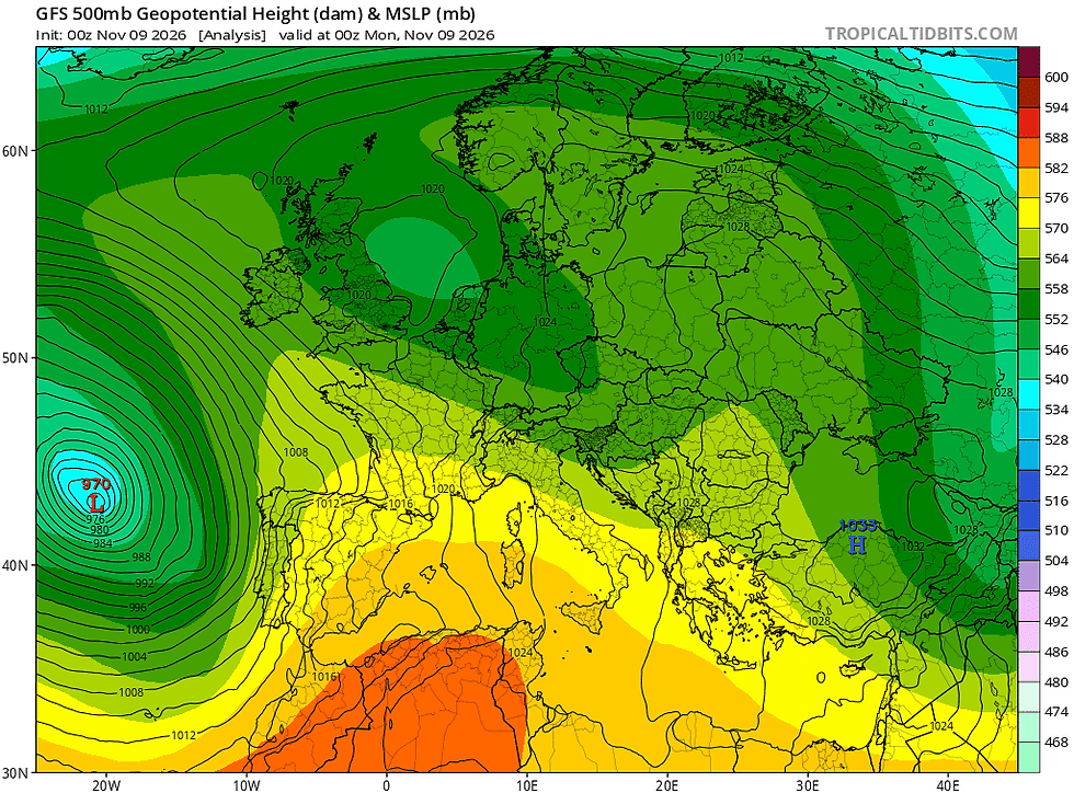

With that in mind, let's take a look at what the ECMWF / GFS outlook....this morning I am using the GFS outlook because it happens to look further ahead than the current ECMWF run. Let us hope btw that the routing of Trump's influence at home recently may tip the balance towards science and climate research again domestically in The United States because we need their help on this one.
So how are we looking ?
Well, we have had a high pressure blocking event in situ for awhile now and as I look out of my window, there's a blanket of fog and the air temperature is nudging 5°C. This high pressure will be nudged eastwards in the first half of this week, with a southerly Atlantic low pressure pushing in. Now this low pressure isn't projected to make much progress eastwards and so what it'll do is introduce easterly winds, some rain for the southern area of the U.K on Tuesday and Wednesday (not much as it looks at the moment) and briefly, milder temperatures for Tuesday and Wednesday. By Thursday though, this low pressure has stalled and we see high pressure out to the west and a very cold low pressure to the east.
When this happens, air is funnelled between them in a northerly direction and so by Thursday we will see more in the way of sunshine, but it'll be accompanied by some bitter northerly winds, with a pronounced wind chill and a run of overnight frosts. In the words of Paul Heaton in that brilliant Housemartins track....'I smell winter'.......Not for long though because by the weekend, high pressure wins the day, we lose that northerly wind, but it'll remain on the cool side, especially at night.
Now then, at the beginning of this blog I talked about probability events. Well the probability of the forecast I have given you is around 60%, according to Meteoblue.com. By Monday, their probability attached to what comes next drops to 15%, so please bear that in mind.
What may come next therefore is that we could see the jet stream drop much further southward and when that happens, the Atlantic tends to win the day. (not always though as we have seen during 'Beast from the East' events)
The projection currently is for the jet stream to drop south and allow an intense low pressure system to push in over the U.K. If this occurs, it could give us our first very heavy rain (across the south of England) for a good while for the first part of next week. It is the position of the jet stream that interests me though because we tend to see the Atlantic airstream dominate when this happens and that means rain and unsettled conditions continuing.
We will see though, but I suggest keeping a keen eye on your forecasts for the early part of next week.
No agronomics this week because 'tempus fugit' for me currently.....
All the best, dig out those buffs and good base layers because you're going to need them :)
Mark Hunt


Comments