
April 7th, 2026
- Mark Hunt

- Apr 7
- 7 min read
Hi All,
A pertinent week for a blog I feel as spring temperatures climb into the twenties and lack of rainfall becomes more and more an issue in some areas of the U.K.
It is often the case that during a typical U.K or Irish Spring, grass growth is either temperature or moisture-limited or indeed sometimes, by both. Take the last few days as an example, temperatures in the U.K have hit the mid-teens, but at night we have had a ground frost. With no rain falling this month for many areas, especially across the south and east of England, areas have dried down significantly from the excesses of the winter. Loss of moisture has also been significant with daily E.T figures climbing to over 3.0mm per day, that's significant when it comes to grass growth and especially growth for Poa annua.
You can see the stats on the output from Prodata Reports below ;

From a growth perspective, talking in Growth Potential terms, I work on a good spring growth day coming in at 0.4 or above. If we look at the chart above for our default location in Thame, Oxfordshire, we see that for April so far, despite some warm, daily maximum temperature readings, the daily G.P has remained low. In other words growth has been slow because of the spring handbrake to growth, low night temperatures. Throw in those higher daily E.T levels / lack of rainfall and we find Poa annua as a grass species hunkering down and displaying minimal growth, whereas Bentgrass species absolutely love the combination of warm day temperatures and more importantly high PAR (Plant-available light).
This creates a potential issue when it comes to presenting surfaces with one grass species (Poa annua) displaying minimal growth, whereas the other, (in many cases) Bentgrass is growing strongly and displaying a broad leaf characteristic as it does so. Bentgrass at a high height of cut (4mm and above) takes on a very broad leaf characteristic which contrasts significantly with the finer leaf of Poa annua at the same cutting height. This growth differential between the two species at this time of year can create an uneven surface. So, of course logic would dictate that we tweak the cutting height down a little and maybe add in a light topdress to remove the discrepancy between the two species, but we need active growth to aid this process and that is something we aren't necessarily getting at the moment.
This is the spring conundrum for growth, yes another conundrum to go with the one we have over the winter when we have sufficient temperature for growth but insufficient light. Life is one big conundrum it seems :)
Now of course this isn't the case for everyone, further north and west we have had a more reliable rainfall pattern and this removes both of the handbrakes to growth, more cloud cover means night temperatures tend to sit higher and of course there's more moisture as well. A quick flick around some Davis weather stations tells me that The North East is still very dry and cold, The North West has picked up a little more rain, but remains cold and Scotland looks pretty much ok rainfall-wise, just waiting for the temperature to pick up. Ireland has now reverted to type in terms of rainfall patterns. with the west and north picking up the majority and the east on the dry side, a very different rainfall picture to the winter when the south and south east picked up a lot of rain. Across The North Sea in Denmark and growth is only just starting after a long cold winter with the odd day hitting a Growth Potential above 0.2, so they're right at the very start of the growth process after winter dormancy.
The first half of this week's warm temperatures will likely produce a growth flush as day temperatures AND night temperatures increase through the first half of the week. For some this will be mightily welcome, more on that one later.

Nature however is in full swing, with the verges bursting into life and spring flowers prominent in their display. Walking through Fineshades Wood near Corby, the first English Bluebells are coming into flower and my favourite, the Wood Anemones (above) are poking out to say hi to this clement spell of weather. The woods are full of the first summer migrants, Chiffchaffs and Blackcaps, along with surprisingly, a real mix of Finches. I stopped at one point as the tree tops were full of birds, I recognised some of them as Goldfinches and Greenfinches, but other calls I wasn't sure about. A quick flick to the Merlin app and all was revealed.

Last week when I was attempting another somewhat fruitless session of catching Trout at Rutland Water, I heard the familiar faint sort of high pitched mewing of an Osprey. Looking up, I spotted not one but three Ospreys appearing out of the clouds as dots, gradually getting larger as they descended. Their calls became more animated and I sure this was because they had just arrived at their destination after the 3 - 4,000 mile migration trip. Some effort that and minutes later I saw my first Swallow, happily feeding up on hatching buzzers and midges after an equally long-haul flight. A great tonic for me after another pretty crap attempt at luring Trout. Me and fly fishing aren't clicking at the moment.

As I worked on my motorbikes in the garage over The Bank Holiday, my friendly and ever-inquisitive Blackbird joined me, sitting on a Scotts Spreader to direct my mechanical workmanship. I am sure it is my mum reincarnated, sitting there chiding me for covering myself in mechanics grime, whatever that bird makes me smile.

Now then, I have talked about the effects of the current weather on turf growth, but why is it like it is ?
Well, principally it is down to our old friend, the jet stream.
Recently we have had yet another SSW event, high up above The North Pole and whether it is this or just a lower temperature differential across Northern America, the result is a slow-moving jet stream that has run out of puff. When it is slow-moving, it often forms peaks and troughs as I have commented upon before and this is exactly what we see now. A pronounced peak pattern in the jet stream that will allow warm, dry air (very warm) push up from Africa, whilst at the same time pushing any rainfall above the U.K. The position of the jet stream has also changed from the winter, pushing further north which means a higher likelihood of peak pattern events and less likelihood of trough patterns and Atlantic low pressure systems.


The upshot is warm and dry, with very little likelihood of rain for the first half of this week. Now with the jet stream as it is, it makes long-term projections beyond 5-7 days doubly tricky, however what we can see is in the second part of the week an Atlantic front tries to push in from the west and brings a band of rain to Ireland. This front is projected (currently) to keep moving eastwards across the U.K through Thursday into Friday. This rain front might even make it into Denmark on Friday. Close on the heels of this rain is another low pressure system that again tries to push eastwards. Currently this is projected to push some showers across Ireland and the U.K over the weekend.
Now here is the caveat and it's a hefty one.

Spring and indeed summer rainfall is much harder to forecast than winter rainfall, so that's why last week's forecast showed a lot of rain for this week and then suddenly the outlook changed and that rain disappeared. It is very frustrating I know, but that's the craic.
That is why I have always liked Meteoblue as a weather forecasting company. They have a lovely 10-day Meteogram that shows the outlook for the next 10-days and at the bottom it is accompanied by a probability. So if you look on the above Meteogram above, below the rainfall columns you can see the probability attached to the rainfall event. Even 4 days out currently, the probability attached to the rainfall at the end of the week is 35-40%, so that means a 1/3 sort of probability of the forecasted rain occurring. Interestingly, the same probability is attached to rainfall at the end of next week. One to watch.
So, don't be disappointed, yes for sure it is a little frustrating, particularly if you are chasing recovery from March aeration and you need both some temperature (which you'll get in spades) and rainfall (though obviously irrigation can be utilised)
The reality though is this is when communication has to come to the fore, where management and members have to understand the concept and effect of low night temperatures and the handbrake on growth.

Before I finish typing this blog, I thought I'd produce a nice cumulative GDD comparison between a Davis weather station located very close to Augusta National and an arbitrary location in England. In this case Uttoxeter. I am using 6°C base temperature for the GDD calculation, so I view this as a relevant growth comparison as opposed to one that utilises 0°C, which isn't IMHO.
It's worth pointing out that this comparison is in no way a negative reflection on the Superintendent in charge of Augusta National, god knows that job must come with a huge amount of pressure and expectation and I take my hat off to him and his team for doing what they do every year. It is simply a comparison of where they are and where we are from a growth stage perspective from January 1st, 2026 because some golf club members and some golf club management (this side of the pond) will make this comparison from a negative perspective during the event. I would like to think the 'Augusta Effect' is diminishing every year as we utilise better tools, better data collation and adopt better, more effective channels of communication.
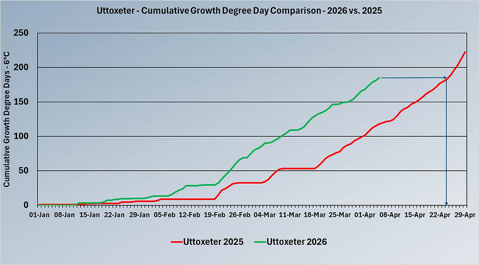
I would also like to point out that despite the recent run of cold nights and warm days and lack of rainfall for some (in some areas), we are in a better situation this spring than last. (in some areas)
For the above location, we are 20 days ahead from a cumulative GDD perspective in 2026 vs. 2025 and that means we have had more opportunity for recovery and growth since January the 1st. Now that date is key because for the clubs that aerated or were able to aerate super-early in January and February. they are home and dry recovery-wise. For clubs that had to wait to the more traditional slot of March / April, this week's warmer temperatures should provide a welcome boost to growth to help get you over the line. The same applies to schools were they have had to transition from winter sports to cricket. Fingers crossed for you all.
All the best.
Mark Hunt


Comments