
May 18th, 2026
- Mark Hunt

- May 18
- 5 min read
Hi All,
May 2026 has been something of an anomaly with average temperatures running 1.5 - 2.0°C lower than normal. To me at certain points this month it has felt unnaturally cold. I pulled up the average temperatures for our default location for the past 5 years and this is how the stats look ;
Mean May Monthly Temperature (in °C)
2022 13.2
2023 12.5
2024 13.8
2025 13.4
2026 (m.t.d) 10.7
Some difference that.
Of course with the rest of May looking to be potentially warmer, no doubt the monthly mean / average temperature will be closer to the 1991- 2020 average, but it has got me wondering quite what's going on. Maybe it is down to that very late, SSW Event weakening the behaviour of the jet stream or maybe something else is at play. Maybe a weakening of the AMOC is behind it ?
The meteorological news is also suggesting a Super El Niño may be developing for the summer / autumn of 2026. This is a significant warming of the Pacific Ocean and it is one of those 'teleconnections' as they are known or in other words, a large scale climate process that can have a significant effect on our weather. If a Super El Niño does indeed develop, it'll be the first since 2015/16 and that particular year we experienced a very mild and very wet winter with significant flooding. No guarantee we will see a repeat as it isn't the only process that affects our weather on a large scale, but one to watch all the same.
Now you'll know doubt have heard weather forecasters hinting of a change in temperature coming our way with a warm, maybe even, a hot spell of weather due later on in the week / weekend. Or you may have read my brief update on LinkedIn last Friday. The fact is that this warm air peak first appeared a week ago on the ECMWF and GFS, so that's something like 10-12 days prior to it appearing. That's why I believe that understanding these longer-term forecasting projections is essential for a modern-day turf manager. Yes, they can change for sure, but if you get a 10-12 days heads up about an increase in temperature or in our case, a sudden increase in temperature, there is a number of agronomic processes that we should be thinking about. More on that later....
Before I do, let's look at what's coming.....


Now, before you get too excited that this spells the start of a long-term heatwave or overtly-concerned from a water reserves or irrigation perspective, following our sustained period of dry weather, this spell may not last. The fly in the meteorological ointment may be another Cut-Off low pressure that forms over the weekend and looks to split the peak of heat and later, drag cooler, Atlantic air back into the picture later the following week. Time will tell on this one. For now expect temperatures to begin to ramp up from mid-week onwards as that warm and critically humid air pushes northwards from southern Europe. Note - humid air because that is important agronomically.
Not only will it push temperatures into the mid-twenties by the end of the week and possibly over the weekend. It may also be accompanied by some very localised downpours, especially on Thursday and Saturday. This is courtesy of low pressure nudging moisture into the southerly airstream and creating humidity and possibly thunderstorms. So quite a volatile feel to the weather going forward but quite a change on what we are currently experiencing.
Definitely some warmth arriving for Denmark, long overdue eh Russell ?
Ireland being closer to the Atlantic airstream means they'll be the familiar south west - north east rain shadow, despite the warming temperatures. That warming effect for Ireland also won't be as significant as for the U.K or Denmark, with high teens, maybe nudging into the twenties the best you can expect. Still nice though considering the weather over the first half of May.
May be handy to have LightningMaps.org on your phone to plot lightning strikes in real time accompanied by radiating circles simulating the sound wave from thunder.
Agronomics
Well, after having such a cold spring so far, dry as well on the whole, though some of us may have caught some rain last week and maybe this week as well.
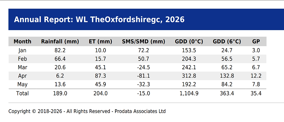
You can see how cool it has been when you look at the monthly total Growth Potential (G.P). If you think that the optimum daily G.P is 1.0, then depending on the number of days per month, the total monthly G.P is either 30 or 31 (with the exception of February of course). March came in with around 20% of optimum growth, similar to February actually, April, 40% and May is tracking just above April so far. March, April and May have also lost more moisture by E.T than has been replaced by rainfall, putting us in a deficit situation. You can see that judging by the cracks in the clay soil around Leicestershire and Rutland and the burnt edges to lawns alongside drives and pavements.
Now the change to warmer and more humid weather will trigger a number of turf management processes that we should be aware of ;
Rapid Growth Potential Increase
With current daily G.P levels tickling along between 0.2-0.3, we can expect these to increase to 0.90 - 0.95, by the end of the week. So this means a significant growth flush, especially in areas that either receive irrigation or have had recent moisture from rainfall. Good timing for a PGR I'd say on tee banks, bunker surrounds and the like.....
Temperature & Humidity = Disease
The sudden increase in humidity will no doubt kick in some of our more familiar late spring diseases, especially Fairy Ring, Microdochium, Red Thread and possibly some Dollar Spot maybe. The benefit of that growth flush will hopefully mean most foliar diseases will be grown out as fast as they appear with no need to reach into the Chemsafe.
Anthracnose and early Dollar Spot trigger ?
Consecutive days of high air temperature > 23°C, accompanied by leaf wetness are a potential recipe at this time of year for an initial trigger for Anthracnose. Now I have talked about this process before, but if you have been on the receiving end of repeat outbreaks of this disease and have therefore built up a spore base, you need to keep an eye out for the trigger event that initiates activity. It doesn't mean you'll definitely see Anthracnose later in the summer / autumn, but you may, dependent on climatic conditions and plant stress levels.
Now for Dollar Spot it may be a little on the early side.
I'll be interested in your feedback because in my mind if we see Dollar Spot after this cool spring, this early, I think it'll be Clarireedia jacksonii rather than the other Clarireedia sp. Please drop me an email on markh@weatherstations.co.uk
Right, I need to pack the overnight bag this week as I'm doing another round of GMA talks, up at Headingley and down at Stoneham. One more on the 4th June over in Ipswich and that's my talks over for 2026. I need a break from them and so does everyone who has listened to me over the years. 😂
Haven't completely made my mind up yet, but I will either trip over some more things I'd like to talk about at a later date via some planned research work this year or gracefully take a back seat and quickly fade into industry irrelevance (and let's face it, it is about time😂 !!) I started doing talks in 1990, my first ever (for a company called Sierra) was at West Bowling Golf Club on the outskirts of Bradford. I was so nervous I couldn't stand up, so I sat down and did it. I still get nervous to this day before starting off, but once I am away, I am away.
Have a good week and all the best....
Mark Hunt


Comments