
20th April, 2026
- Mark Hunt

- Apr 20
- 6 min read
Hi All,
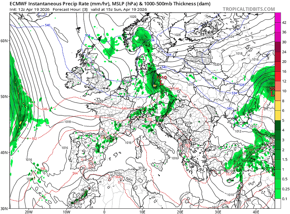
So our topsy-turvy spring season continues, with a current run of dry weather, warm (ish) days and cold (ish) nights. The reason for this is the strength and orientation of the jet stream. Now, whether it is due to the run of Sudden Stratospheric Warming events, with the latest in early April, (a very late event by all accounts), I am not sure, but it seems like it to me. Looking at the projections from GFS and ECMWF long-range models, we can clearly see that the shape of the jet stream has moved away from the strong Atlantic jet of January and February, to a weak, severely-undulating pattern. The position has also changed from sitting below the U.K to above it, thereby allowing high pressure to dominate the picture.

I have to admit to despairing about the state of the world currently. Whether it's the latest iteration of AI that threatens all of our financial security with no ethical debate about whether we should allow this to affect our lives. Seemingly a few companies in the hands of a few, rich (American) men have decided it is all well and good, the same with Social Media. Both I view as a malaise on our society.
Reading New Scientist last night, I was concerned (but not surprised) to see that the scenario sensationalised in 'The Day after Tomorrow' film is now highlighted in research, with a weakening of the Atlantic conveyor, the system of currents that currently provides the U.K & Ireland with a milder climate. This has been predicted for a long while as freshwater melting from the Arctic interferes with the normal current circulations across the world. Not wishing to be alarmist so let's just hope that it is merely a short-term fluctuation and will revert to type, at least now we have a robust system to monitor it. Read about it here in New Scientist.
On the other side of the coin, the thing that keeps me positive is nature. It's in full swing at this time of year and let's face it, a drier spring with more sunshine is good for insects and therefore bird species as well. My resident Blackbirds have already got their first brood chicks hatched and well grown on, the same for Blue Tits. As I cycled yesterday in a vain attempt to please my bitchy Garmin from stating that my training is 'under-productive' currently, I was at times besieged by clouds of buzzers and Hawthorn flies (St Mark's Fly). Great to see and for the newly-arrived House Martins and Swallows, a veritable feast. Spring flowers are also in evidence with lovely displays of Bluebells and Cowslips scattered around. My resident Hedgehogs are also getting in the mood with regular 'Sumo' bouts on my patio. If you think that they are mild-mannered creatures click on my video below and you'll see otherwise. The 'victim' sits there curled up, often on its side until it deems it's ok to right itself and either make a dash for cover or sometimes cheekily resume feeding until the situation repeats itself. Priceless to watch.
Onto the weather and what is going on at the moment....

Just look at the GFS projection above. Watch the behaviour of the closest, low pressure to the U.K as we go through this week and rather than moving west-east as would be normal, we can see it stalls in The Atlantic, detaches to form a temporary cut-off low and actually moves in the opposite direction. With the jet stream (dark green line at boundary of cold and warm air) sitting far to the north of the U.K, it means we are likely to be at the behest of high pressure. See the slide below, lifted from my current GMA presentations showing the path of the jet stream in red.

Technically-speaking we have seen the jet stream form into an Omega Blocking pattern since the middle of March and that means less rain, more prolonged dry weather and a dry-down of the soil. Now in some areas I freely admit, a dry-down is exactly what was required after a very wet winter. For others, it means a significant soil moisture deficit is beginning to build, it all depends on how much rain you had over the winter and of course your soil type. Heavier soils have retained moisture well, lighter ones have not. If you go to the east of the country, across The Fens, significant soil blows are evident, such is the state of moisture loss and the light soil type.
An Omega Blocking event at this time of year isn't entirely good news because for all of us growing turf it makes life a bit tricky. For playability mind, it is great news, so it is a double-edged sword.
Now the reason why the current weather scenario is 'tricky' is multi-faceted.
Firstly, high pressure means it is likely to be mainly dry and as we will see shortly, dry isn't really what we need at the moment for most areas because we have been dry for the best part of 5 weeks now in the main, with more moisture being lost by evaporation and transpiration than has been replaced by rainfall.
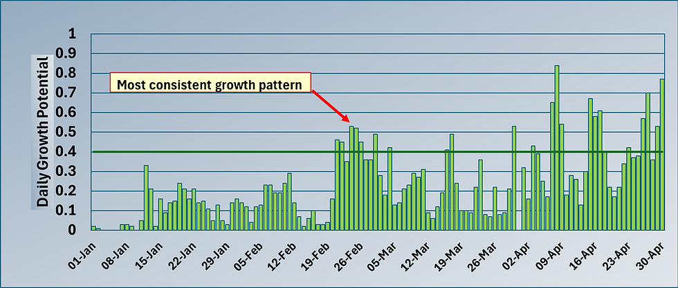
Below are snippets of the Spring Growth Dynamic Report lifted from my default location @ The Oxfordshire, Thame, U.K. Thanks as always to Sean Wilson for being able to share this data ;


From the middle of March we can see that the rainfall pattern changed from significant rain to very little rain. That's the point when the jet stream ran out of puff, formed into the omega-shaped pattern (shown above) and our weather dynamic changed to what we should by now I guess appreciate is a typical default for spring now in the U.K and Ireland.
So we are dry.

The next issue relates to wind direction. High pressure systems dependent on their orientation, tend to pull in colder air on their leading edge, so that means a northerly wind aspect, trending towards north easterly and easterly. These type of winds tend to be cooler (and drier) in nature at this time of year and that has an effect on growth.
The bigger effect though from a high pressure system is that we tend to see more sunshine during the day, less cloud cover (because the air is drier) and as the sun sets, the temperature drops and often we see (as we did this morning) a ground frost. As I have explained countless times, night temperatures are the handbrake to growth, the lower the night temperature, the lower the GDD or G.P figure, the less growth we see.
Look at the above Prodata Report snippets to see how many days of good spring growth (defined as ≥ 0.4 from a Daily Growth Potential perspective). For March I count 5 days out of 31. For April I count 8 out of 19. By the way, during that same period I also count 8 ground frosts including todays.

Now last week we did see a short growth flush when we had 4 days of consecutive G.P's≥ 0.4 and that meant a flush of Poa annua seedheads for many as an under-stress Poa annua plant took full opportunity to grow and express seedheads.
If I look further eastwards across The North Sea, the situation is much worse with winter refusing to lose its grip on Denmark and Scandinavia. With a 'recalcitrant' jet stream, Scandinavia is still dominated by cool / cold weather and a total lack of growth. This situation won't change until the jet stream dynamic changes. To give you an idea of how far back they are in Denmark, their total GDD (6°C base temperature) up to and including yesterday is at 32.9 since Jan 1st. We hit that figure on February 7th. In short that represents little or no growth.
So is there any sign of the jet stream reverting to type and bringing what used to be the default for April, sunshine and showers ?
Well, the long-range models extend right up to the beginning of May and currently (that can change mind) they are showing (GFS & ECMWF) no real change to the shape or position of the jet stream. So I think we will check out of April with a soil moisture deficit (in most locations) and a suppressed growth habit. Now 100% I accept it isn't all bad news, dry weather means great conditions to get out and play, so that's one box ticked, it's great for revenue. If you have your course / pitches at a good state after the winter then this run of weather while testing, isn't totally bad news, but for golf Poa annua seeding remains an issue for many. If I see any change in the current pattern, I'll flag it up on a mini blog but for the time being we just have to deal with what Mother Nature has thrown our way and be patient.
In the mean-time, all the best
Mark Hunt


Comments