
April 27th, 2026
- Mark Hunt

- Apr 27
- 4 min read
Hi All,
Well our seriously dry April period continues but there are potential signs on the longe range forecast that the long-term blocking jet stream event that has held high pressure across the U.K & Ireland is coming to an end. If we look west to the North Atlantic we can see a succession of low pressure systems stacking up to the west of us. My gut feeling is that eventually these will displace the blocking event, push it out east and allow a more 'Atlantic' feel to our weather. If so, this will return us to a scenario of rainfall (hopefully).

Further east across Denmark, the movement of the high pressure eastwards will channel up some warm air from the south and finally the spring (summer) will start after a very long winter. I have to reach to Google translate for this phrase but I think it's apt.....'det har været længe undervejs'....It has been a long time coming...

Rutland Water's Hambleton peninsula was beautiful yesterday in the hazy, spring sunshine with a display of Greater Stitchwort and native Bluebells. The name Stitchwort points to this plant's use as a remedy for Stitch when out running / exercising. I did try eating some leaves and they weren't 'flavoursome'. Maybe it works on the same principle as Gammel Dansk, a Danish bitters liquor which tastes, frankly awful and thereby takes your mind away from anything else ?
As I fly fished into the fading light, I could hear 4 different Cuckoo's calling at the top of the South Arm of Rutland Water and I wondered if these birds were celebrating their arrival after that long migration from Africa, despite their sinister life style.

Back to the weather, so where are the signs of change in our weather outlook ?

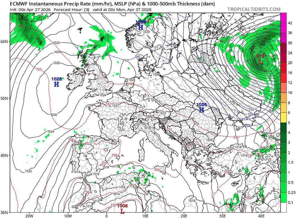
To me the key process in this transition is the formation of a cut-off low pressure system early on this week. I have watched these weather phenomenon over the last couple of years and what they 'tend' to do is pull down Atlantic weather fronts into our weather picture. Above is a snapshot of the ECMWF weather picture and you can see the cut-off low pressure system detaching from the jet stream. This low pressure will then move westwards and eventually sit off the SW Irish coast and then later in the week it will reform with the jet stream and pull down a low pressure system across the U.K & Ireland. Not a great amount of rain and it will be hit and miss but it's the first sign of a change in my view. Now this change won't be instant, it will sow the seeds I think to the potential for more consolidated rain next week potentially. The ECMWF and GFS don't agree on this so it could easily change but I am confident (ish).
They'll be some showers around today across Scotland and moving south across northern England into The Midlands maybe later in the day (fingers crossed). At the end of the week as well, some more rain creeps into the forecast courtesy of that nearby low pressure system, with Ireland and the west of the U.K most likely to catch some showers. So nothing earth-shattering, but a subtle change in the weather dynamic for me that could point towards a wetter first half of May, maybe...
In the meantime this week, high pressure is still calling the shots with temperatures building during the week to the low twenties over the southern half of the U.K.

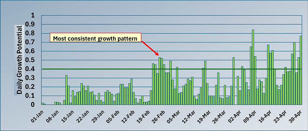
Those critical night time temperatures will still be in single figures but higher than of late so that means our growth potential will also edge up from its presently low level of 0.25-0.4 towards 0.6 - 0.8. Much better and providing a nice kick of growth as long as it is not moisture-limited. This flush will more than likely kick off more Poa seedhead development in the canopy and hey we are in the last week of April / first week of May, which is bang on time for seedhead expression, even though the GDD marker was passed weeks ago.
Below is a snippet from Prodata Reports summarising the twin issue of an extremely dry April with a sum total of 3.8mm of rain vs. 72mm of moisture loss from the soil and grass plant by Evapotranspiration (ET).

I have looked back at the last few April's for our default location and summarised the same stats below ;
Year Rainfall E.T Soil Moisture Surplus / Deficit
April 2022 19.6mm 77.9mm -58.3mm
April 2023 54.2mm 62.3mm -8.1mm
April 2024 72.0mm 66.4mm +5.6mm
April 2025 16.2mm 70.5mm -54.3mm
April 2026 3.8mm 71.9mm -68.1mm
So you can see (hopefully) why April 2026 has been a tricky month from a moisture management perspective even comparing it with the warm / dry April's of 2020 and 2022. I am confident that April 2026 will go down as one of our highest E.T April's on record.
So we know moisture management has been one of the issues, the other is consistent growth. When you look at a snippet of the air temperature profile over the last week (below), you can see how it resembles a side profile of The Andes, with low night time temperatures and warm day time temperatures.
In the graphic below I have compared the 25th and 26th of April and you can see on the graph a subtle difference with the 26th showing a higher night temperature (4°C vs. -2.3°C the night before). Hardly a warm night but that increase in night temperature realised a 50% increase in Growth Potential, from marginal at 0.38 to good at 0.57.
That's how significant an increase in night temperature is on growth.

So hopefully this week we pick up some warmth for areas that haven't seen it yet (Denmark) and the beginning of some rain showers in areas that haven't seen significant rain for 6 weeks.
Fingers crossed and all the best.
Mark Hunt


Comments