
December 15th, 2025
- Mark Hunt

- Dec 15, 2025
- 8 min read
Hi All,
Welcome to my last blog of 2025, next week I have an appointment with 'The Blonde Assassin' up at Nottingham Hospital for my routine shoulder work, so I won't be up for much but I might try and give a 'heads up' if I see a significant change with the current weather projections.


As I walked around the beautifully tranquil Fineshade's Wood yesterday everything had a winter feel to it, the colours and the landscape looked wintry despite it being mild enough to walk without a coat. During the walk I heard a Tawny Owl hoot, right in the middle of the day, so I turned on the Merlin app and returned the call myself mimicking the Owl. Now, I have spent a lifetime fishing into the evening and night, first around the local canals here and then on the Trent and in The Fens. To keep myself amused in the long periods of nothing happening sitting on my chair in the darkness, I have called in Owls by mimicking their calls. Even to the point where they have been hovering above my head to see what on earth was making this racket. Great fun.
I was therefore delighted to see that the Merlin app had identified my own generated call as coming from a Tawny Owl, brillbags. Later in the walk I found a small flock of Red Crossbills, there red breasts shining in the afternoon sun. I could hear the loud click as their uniquely-adapted bills prised open pine cones to get at the seeds inside. I flicked Merlin on again and it identified them as Greenfinch, which they obviously weren't. A good App but not entirely accurate quite yet. I use it to assist in identification rather than to tell me what the bird species is definitively.
By the end of the walk the sky was full of Mares Tails, a harbinger of more unsettled weather to come.
We are less than a week from The Winter Solstice, the lowest point of the sun on the horizon. Thereafter we are heading back to spring and eventually summer.
For the sodden west and north of the U.K that can only be a comforting thought. For the still water-deficient east, that remains a concern with reservoirs barely 70% full, here we still need every drop of rainwater we can get. On the west of the U.K, monthly rainfall totals are already between 150-200mm after the first half of the month, so here flooding is a concern as soils have long ago reached saturation point. Playability is also a major concern. It really is a west-east divide when it comes to rainfall this autumn / winter. Here in The Midlands where the main water storage reservoirs are located we are sitting around 60mm for the month so far and in need of more rainfall, daft as it may sound to people in the west and north.
Of course many people's thoughts are looking towards the calorific armageddon that we call Christmas and whether it will be a white one ?
Well what can I tell you here and now ?
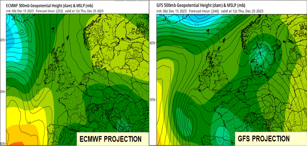
If you look at the current long-range model output for Christmas Day from the ECMWF and GFS models, what we can see is that the weather thematic is changing. For a good while now we have seen a dominant Atlantic theme to the weather aided by a strong jet stream pushing weather systems from west - east.
Well that looks to me like it is going to end. Now maybe this is a result of the end of November, Sudden Stratospheric Warming event I discussed in previous blogs because the likely shakedown from this is a stopping / reversal of the jet stream. This then allows northerly and easterly air to come into play and in 2010 and 2013 was the primary cause of the so called 'Beast from the East'.
In the GIF's above you can see that in the GFS projection they are suggesting easterly winds coming into play and I think that will come to pass. It is still very much up in the air but I think we will see a continuation of that run of Atlantic low pressure systems and mild, south westerly winds up until around the 23rd of December and then there is a chance that high pressure will build and spin those winds first northerly and then easterly.
Christmas Day itself would if this pans out turn out to be a quiet, cold, dry and potentially foggy sort of affair with very little wind aside from that created by large scale intake of carbohydrates :)
It is what happens after Christmas Day that I think is still up in the air but looking at the ECMWF model, it is poised for a cold air, easterly run of weather thereafter. One to watch for sure, especially for Denmark being closer to the eastern continent. Over the other side of the pond I was talking to a friend of mine who lives in Colorado and I couldn't believe that currently they are seeing temperatures of around 20°C in Denver with no snow and no likelihood of any. Over there the jet stream has formed into a classic heat dome - peak shape and this is allowing unseasonably warm air right up into the northern states of America. No surprise I guess that there's a surplus of hot air Stateside eh ?
I can see it playing havoc for the American Superintendents who have normally put their courses to bed under snow cover and freezing temperatures. It looks like it could be a bit of a nightmare from a Snow Mold perspective. Thoughts are with you guys and girls trying to cope with maintaining grass in the north and transition zones when the weather swings wildly like this.


From the GIF above, you can see we have two low pressure systems between now and Christmas, so we will see a continuation in the currently mild, wet and windy weather pattern. It is the one that is projected to arrive this weekend that is the key marker because as you can see, it sinks down the west coast of the U.K to a position south of England and then pulls in an easterly wind across its trailing edge. This low pressure could bring significant rain to the southern half of the U.K, if (and it is a big 'if') it plays out this way. Before that we are also in for some pretty stormy weather on Thursday with strong winds and heavy rain expected I am afraid. Much of this will be across Wales and the west but also the southern half of the U.K. Denmark will see a similar pattern, that of mild, wet and windy weather this week and into the weekend as these Atlantic fronts push across the U.K, then The North Sea and into Scandinavia. Again for you guys and girls I see the 23rd as being the key day when this run of westerlies comes to an end and those easterlies kick in.
Agronomic Notes
Spray Days and Microdochium nivale
Now some of you located in the sodden west and north of the U.K (and Ireland) will read this and sigh because even if the weather was conducive to spray, the saturated ground conditions will make it impossible to get a sprayer around the course or onto a pitch. For others its a case of spotting a window to apply a pre-Christmas tonic, iron. hardener, fungicide or combination thereof. Opportunities are limited in my view falling to either the early part of this week before those low pressure systems wind in or possibly (and this one is less certain because of the uncertainty in the forecasts) the early part of next week before Christmas. My concern I guess is that a high pressure system kicks in over Christmas and provides a spell of muggy, heavy dew and mild air before those easterlies arrive (if they indeed do) after the Christmas period.

We have seen it many times before that the period between Christmas and The New Year can be bad for Microdochium and this year we have a lot of scarring already present on turf. Rather than new infections being the cause for concern, it is more likely to be 'flare ups' on the edge of an existing scar where the fungal disease population is at its highest. So you see this pattern of disease scar radiating outwards, with the centre recovering and the active edge displaying that familiar 'smoke ring' of infected plants. Now, truth be told once you have a large degree of scarring it is very difficult to stop the radiating pattern moving outwards when climatic conditions conspire to encourage fungal activity. Even in the old days of Iprodione and Chlorothalonil, contact and protectant fungicides respectively, it was often the same, despite multiple sprays. In the present-day scenario, the objective is to 'ring fence' the area of activity with a pre-Christmas spray and enhance turf health / appearance at the same time (if it is practically feasible that is) and that's why spray days at this time of year are so important.
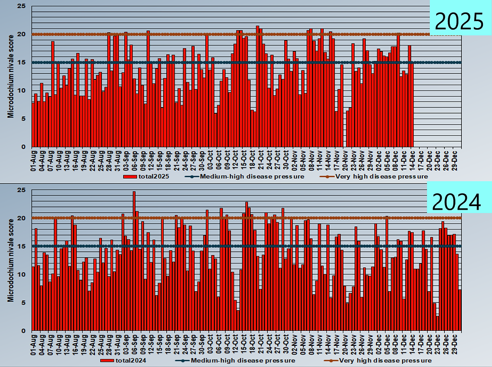
2025 vs. 2024 Microdochium nivale disease pressure
The above charts show a comparison of Microdochium disease pressure for 2025 vs. 2024 using a Central England location. What we are looking for is the days of consecutive pressure between the black and red lines. That's what causes us the most issues rather than the odd day of very high disease pressure itself.
In October 2025, you can see we had two periods close together of consecutive disease pressure, the first for 6 days, the second for 4 days. We then had a 10-day period at the beginning of November which caused a lot of disease scarring for many turf surfaces, primarily Microdochium but still some Dollar Spot as well. Finally in December so far, we have seen another 8-day consecutive spell of disease growth. That's a total of 28 consecutive high disease pressure days spread over October, November and December to date. That in a nutshell is why we have seen plenty of scarring.
If we look at the graph below it for the same location in 2024, we see a different picture. Things began earlier at the end of August, beginning of September with 5 consecutive days (3+2), followed by 4 days later in September. October gave us 3 separate periods of high disease activity spanning 4, 5 and 5 days respectively. Into November and we saw shorter periods of activity, 3, 2 and 2 days, much shorter duration than 2025 and therefore less damaging. That is one of the reasons why we saw less damage in 2024. Now for the clincher, moving into December we saw a long consecutive period of activity, 5 days, from Christmas Day up to and including the 30th of December when conditions were conducive to disease formation. This was caused a a high pressure system bringing in mild air temperatures and long periods of dew formation, not just at night but during the day as well.
This is the type of weather pattern we have to watch for this year.
OK, that's me for another week and indeed another year unless I get a chance to update next week. All that remains is to thank you, the followers of this blog for taking the time to read it and come back to me with feedback. Thank you, it is truly appreciated by me.
Wishing you a relaxing and peaceful Christmas and all the best for 2026.
Mark Hunt


Comments