
June 15th, 2026
- Mark Hunt

- 6 hours ago
- 6 min read
Hi All,
Apologies for not committing a blog to this platform (as opposed to my short updates on LinkedIn) but life is hectic. I managed to escape to my beloved Meyrueis in France for a chill out, complete a series of talks with the GMA (thanks to everyone at the Grounds Management Association for making it an enjoyable process) and make a start in moving house to Rutland.
Meyrueis is in The Cevenne, a beautiful part of France punctuated by limestone canyons and rolling countrywide known as Le Causse. The old style buildings in the town provide lots of nesting sites for birds and you can see the number I recorded just outside the hotel. Along with that there were Alpine Swifts, Crag Martins, House Martins and Swallows. Black Redstarts were numerous as were Wagtails. It made me think how our modern day living and house design in the U.K precludes nature and it's why my new house is going to buck that trend.

It was a great year for Butterflies there with numerous Marbled Whites, Blues and Swallowtails present in the town. Obviously it isn't an intensive agricultural area, though farmers do grow Wheat, Barley and Rye locally and there's a lot less dog owners I noticed. Still in the U.K, we have the farcical situation here where you can apply a Neonicotinoid insecticide that is banned in agriculture to your pet as a flea and tick control and then let it swim in our waterways. Lots of evidence of the harmful effects this has on our insects both in fresh and saltwater.
I see there's been a lot of talk about the Super El Niño or a Godzilla El Niño as I saw it described by one tabloid, looking as usual to sensationalise what is a normal, cyclical weather phenomenon. OK, a Super El Niño is less common, the last one occurred in the winter of 2015/16 and then previous to that, 1998. We have to remember that it is occurring a third of the way round the earth from us, it won't have built till later this year and there are a myriad of other teleconnections that interact with this weather event before it gets to our shores.

When it comes to discussing its potential effect on our weather, to a certain degree we are in the dark here because we haven't had a Super El Niño when the global temperature are as high as they are now. You can see this from the chart above published by The Met Office. What we do know is that a Super El Niño puts more energy into the atmosphere in the form of heat released from The Pacific Ocean. This energy does indeed have the potential to interact and change the position and strength of the jet stream and in so doing change our weather, but how it does so and to what degree are not clear. So for people to publish a sensationalist headline in a tabloid or on social media is plainly false. Just crap, more crap for our overloaded brains to process.
The fact that we have more energy in our atmosphere does of course increase the chance of higher temperatures / heatwaves, but at the same time, higher air temperatures mean the atmosphere can hold more water vapour. For every 1°C rise in air temperature, the atmosphere can hold 7% more water vapour, so an increase in temperature can of course increase the potential for heatwaves, but also for more intense rainfall. The last time we had a Super El Niño at the end of the year, we had a winter characterised by very mild temperatures, wind and rainfall, with very few cold spells. Let's see what happens this time eh ?
One process you won't need to worry about is the ocean temperature off America as that Orange chap's administration across the pond has decided to physically remove the set of ocean buoys utilised to monitor the sea temperature off the States, read about it here.
What is the motivation to do this, to physically remove data monitoring of one of key processes linked to our changing climate ? Could it be that they already know that our ocean currents are changing and don't want to have the data there to show this ? His administration are climate deniers as we know and this latest move just beggars belief. Still you can't worry about what you don't know....
OK, off my soapbox and onto our weather.
Well the last time I posted, we were heading towards a heatwave at the end of May and that's what we got, with record temperatures for the month and a run of extremely high, daily E.T levels.

The chart above shows how the mean daily temperature peaked along with daily E.T levels, with 9 days > 5.0mm moisture loss from the soil and grass plant.

Thankfully since we have had a cooler and wetter interlude with more rain falling in June than we got in March, April and May combined as you can see from the data above !
General Weather Situation

It's a good job we had this cooler, wetter interlude because we look to be heading towards another heatwave building from next weekend and extending into and including the following week. Now when we have one of these events, the exact detail about how and where that hot air plume will form isn't fixed so expect it to change between now and next week but it does look to be significant as I sit and type this.
For this week we have low pressure still calling the shots for the first half of the week at least which means we stay cloudier, on the cool side but heat will begin to build as warmer air from the advancing high pressure begins to feed into our active weather systems. This means humidity will remain on the high side and that has a knock-on effect in terms of disease pressure, more on that later.
So, expect a sunshine and showers type-scenario for this week and even extending into the weekend as an Atlantic low pressure will usher in rain across Ireland, North Wales, the north west of England and Scotland. Further south will see less rain of course because the emerging high will push the cooler, moist air further north. So one to keep an eye on as we move through the weekend and into next week for the U.K & Ireland. Denmark I think will be cooler because the leading edge of that high pressure will feed down some showers and a prevailing north westerly wind into Jylland and further east across Sjælland. The heat will come but just a bit later than for the U.K & Ireland.
Agronomic Notes
An interesting and challenging year so far I think you'll agree. A very wet start to the year, then the taps got turned off in the middle of March, followed thereafter by a cold and dry Spring and then a flick of a switch in late May took us from 'hardly growing' to a flush of growth and record temperatures. We of course have to take it all in our stride but we also have to have one eye on what this means for turf health going into the summer.

So those high temperatures at the end of May were accompanied in some areas by leaf wetness and that was enough to create an Anthracnose trigger event. Now this doesn't necessarily mean you'll see Anthracnose because firstly you have to had a spore base from previous activity in past years and secondly this is only the start of the process. The plant needs to experience significant stress levels thereafter and these may or may not happen (although I believe the chances are high this summer). Now we have a well-trodden path in terms of IPM and BMP's for this disease which I am not going to repeat again you'll be pleased to know, other than to say it boils down to managing your grass plant health effectively. I think the end of June will see another trigger event possibly.


As for Dollar Spot, we have had a couple of gentle (ish) peak events, one that accompanied the heat and humidity at the end of May and another in early June as we saw that cooler, but more humid air push in from The Atlantic. I think we will see this move up again this week and through next week as that warm / hot air pushes up and is accompanied by moisture in the atmosphere. I am wondering if anyone has seen significant activity in the U.K & Ireland so far ? Please drop me an email to markh@weatherstations.co.uk to let me know.
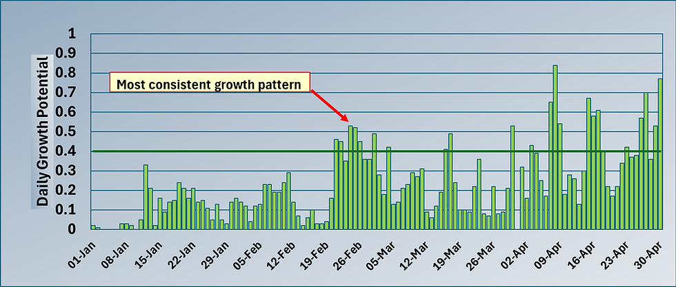
Now, of course that combination will also kick off more Fairy Ring activity and some Microdochium, but with the grass plant growing reasonably well (albeit no doubt under regulation), this shouldn't present too much of an issue other than to say it is a balancing act between growing it out and producing fast surfaces when the daily Growth Potential suddenly increases. A tricky line line to thread for sure.
For now the recent cooler and wetter weather with low daily E.T loss has hopefully allowed the grass plant to stabilise after the heat stress at the end of May. That's the advantage of an Island climate, we don't tend to get one set of weather dominating for too long (famous last words maybe) and that allows the plant (and us ) some respite.
All the best.
Mark Hunt


Comments