
September 29th, 2025
- Mark Hunt

- Sep 29, 2025
- 6 min read
Hi All,
Well, I guess there are some bleary eyes this morning after staying up to watch the enthralling end to one of the most hostile Ryder Cup events I have witnessed. One of the most hostile ? Well actually, the most hostile, with fans behaviour transcending common decency and respect to the players in this famous meeting of USA and Europe.

Symptomatic of where American society is at the moment under Donald Trumps leadership ? I think so.
The sad thing is that the debate above over-shadows the actual game of golf that was played, the brilliant start Europe made and the fantastic fightback by the Americans which took it down to the wire. Ultimately the Europeans let their golf do the talking.
Let us hope that when the Yanks pitch up at Adare Manor in September 2027, we are the better people and don't reciprocate. Just give them a sound thrashing mind and send them packing with their tail between their legs.
There was another great sporting event yesterday, over in Motegi, Japan, where Marc Marquez claimed his first MotoGP world championship for 6 years, after being near crippled by injury. Having 4 operations on his damaged right arm, the last of which required the bone being cut and rotated 30° before re-fixing it. He isn't my cup of tea but his fight back to this level is inspiring. Fair play to him. And let's not forget the England ladies winning the Rugby World Cup !
One more day and September is past for another year. I can still see the last families of Swallows and Martins over my home town and Rutland Water, feeding up before commencing their long journey to Africa. I haven't spoken about my resident Hedgehogs for awhile and that's because I have only had nightly visitors with no one staying, until recently. That has changed over the last few weeks and honestly I can't quite work out what is going on. I have a large Hedgehog and a baby one in the garden, I also have these two, shown in the video above, who are obviously from the same family as they tolerate each other. My wildlife camera chimes in at 20:10pm on the dot every night to see these guys leave their home and head out into my garden, you can set your watch by their activities. So happy that they have chose my garden to live. Now to keep them healthy and the garden Badger-free because that is the threat they faced last time as a local Badger developed a taste for Hedgehogs, biting off their faces, prior to eating them. Cuddly animals Badgers eh ?, don't think so...

Onto the weather.......
Currently the weather maintains its unpredictable nature from a forecasting perspective with the daily updates of the GFS changing their output significantly.
No AI-contrived benefit from forecasting at the moment as far as I can see.

At the end of August, The Met Office announced their list of new storm names for this storm season that started on September 1st, 2025. It is a bit unfair because every season it resets to the letter A, so anyone with a name beyond 'K' is highly unlikely to have a featured storm named after them. So the first named storm will be called Storm Amy and it could ('could') be making an appearance next weekend according to the GFS.

Now if you look at the GFS output above, you can see an interesting schematic, with a low pressure system sitting over southern Central Europe. This low pressure will in my view 'pull' an approaching Atlantic low pressure into our weather for the weekend leading to exceptionally strong winds and rainfall, particularly for Scotland. This could possibly be the first named storm of the 2025/26 storm season and so will be called Storm Amy. Its exact path and positioning will probably change as we progress through the week but as I speak it is already appearing on forecasting radar.
So the weather dynamic for this week is split between Ireland and the north west, including Scotland and England and Wales. The former will have a week of sunshine and showers, interspersed with heavier spells of rainfall, these will increase from mid-week onwards and as we get into Thursday, a nearby low will bring heavy rain to Ireland, potentially followed by Storm Amy impacting Ireland on Friday. The west of Scotland has a similar forecast as the tracking for the rain this week from The Atlantic is on a north west trajectory, across Ireland and into western Scotland.
For England and Wales, we will see a calmer start to the week with plenty of autumn sunshine and some ground frost in places on Monday morning. As we progress through the week, we will build cloud cover on a southerly wind, so staying mild and potentially humid with that wind direction. Temperature-wise I'd expect to be mid to high teens during the day and 8-10°C at night. As we approach Thursday evening, that Irish low pressure will push rain eastwards into western coasts and then across the whole country, accompanied by strong south westerly winds. There follows a brief hiatus before Storm Amy rocks up and winds up the wind speed and rainfall for the weekend potentially.
Denmark looks to have a settled week with high pressure across Central Eastern Europe ushering in light, south easterly / easterly winds, with the odd shower as well through this week. Mid-teen temperatures during the day and high single figures at night. All change come the weekend with Storm Amy pushing her strong winds and rainfall across The North Sea on Saturday morning to bring strong winds and rainfall to Denmark.
Now it is caveat time, the path of Storm Amy may indeed change as we progress through the week, such is the unpredictability associated with our forecast, but it is one to watch.
Post-Storm Amy ? Well I think we will be set fair in the path of the jet stream, so pretty changeable autumn weather, with strong winds and rain a feature. There is a faint suggestion of high pressure building from the 9th of October, but that's a long way away meteorologically.

Agronomic Notes
I thought I'd start the agronomic part of this blog with a bit of compare and contrast. Using data from Prodata Reports for our default location in Thame, you have a summary of 2024 vs. 2025 y.t.d.
By the end of September 2024, we had received +713.4mm of rain and -579.5mm of E.T to give us a theoretical moisture surplus of +133.9mm by my calculations.
In 2025, the same stats reads +381mm of rainfall and -655.3mm of E.T to give -274.3mm soil moisture deficit.
That's a 400mm+ difference in soil moisture status (> 16" of rainfall) comparing 2025 with 2024 for this location.
So we go into this autumn / winter in a much drier scenario with our soil drier, our water table lower and water storage reservoirs laid bare by drought. In short we have some catching up to do. Despite welcome rains in September, which for the second year running made September one of the wettest months of the year (so far anyway in 2025), we have some way to go to readdress our water status.
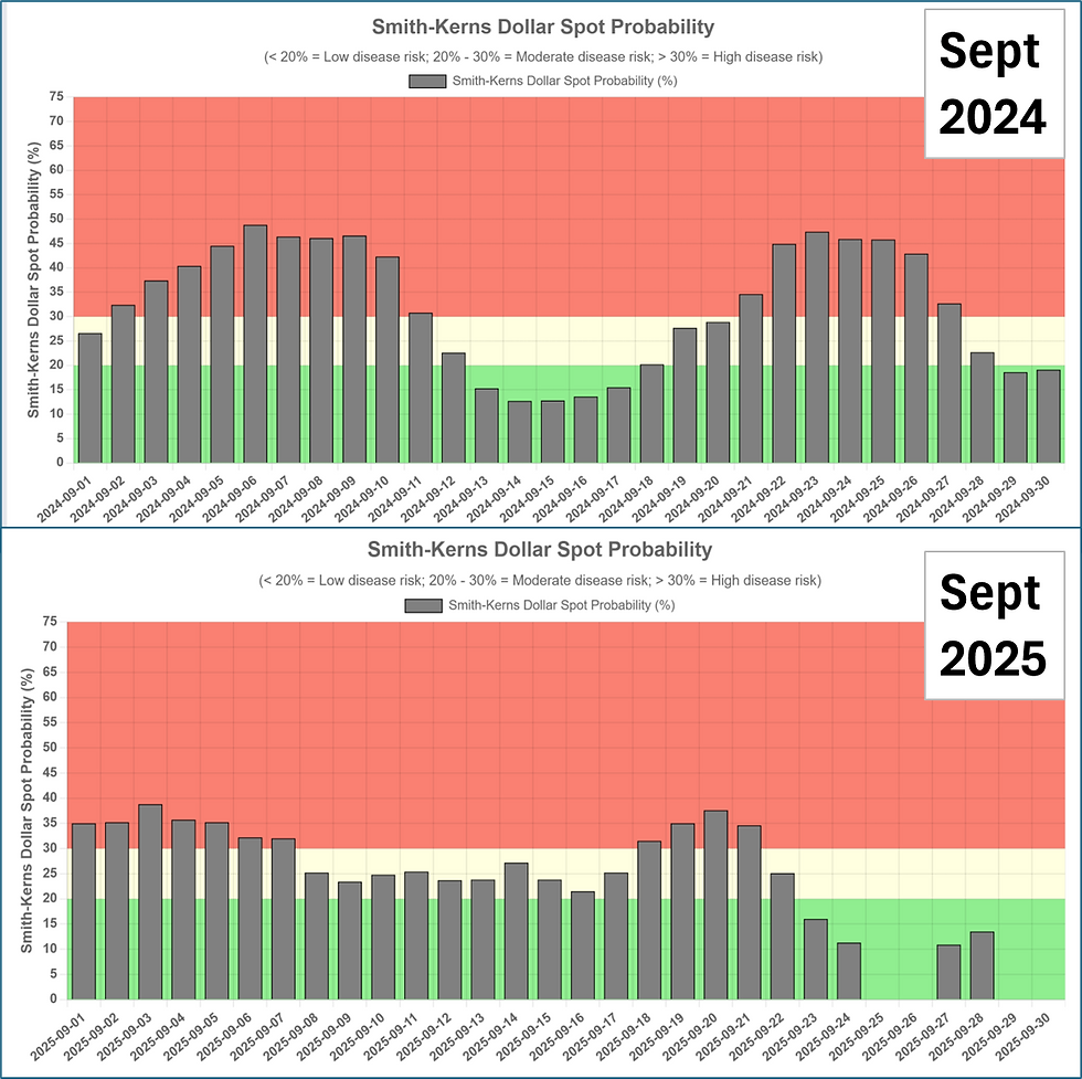
As a summer, 2025 showed minimal rainfall and higher E.T levels vs. the previous year BUT there was just enough rain at just the right time, to keep things from regressing back to a 2018 scenario. Last summer was hot but also humid, this summer drier and less humid as a consequence, so less disease pressure for one from Dollar Spot. September is usually one of our worst Dollar Spot pressure months, but if you compare 2025 with 2024 (below), it is clear to see that the pressure this year is less.
Now that is interesting because Dollar Spot as a fungus doesn't produce spores, rather it survives on mycelial mats formed during previous periods of fungal activity. So if we have had less pressure this year, then logically this should mean less survival structures produced for the following year, maybe ?
Of course we also get to think about Microdochium from a disease perspective and in this case the opposite in terms of disease potential is true. Microdochium nivale spores survive better in drier conditions, that's why you often see the disease in the spring time affecting your driest, non-microclimate greens. The spores have survived the winter better on these greens than your wetter ones. So we have had a dry summer and to me that means a higher potential for Microdochium spore survival and potentially more pressure in the autumn 'if' and it is an 'if' we get the conditions conducive to this disease. If we have a wet autumn then I think we will see less pressure.
The last area is worm activity and here we would expect with a drier soil profile than last autumn, less activity, at least initially in my mind. Last autumn we had really bad activity, really early, after the very wet September of 2024. There was still heat in the ground and with plenty of moisture, casting worms were a big problem. I see some clubs are experimenting with topdressing fairways to decrease the detrimental effect of casting. It will be interesting to see if this practice is 1) Beneficial and 2) Sustainable long-term with our (England) current sand supply issues.
OK, that's me for this week's blog, all the best for the coming week and keep your eyes on potentially Storm Amy at the weekend.
Mark Hunt


Comments