
July 21st, 2025
- Mark Hunt

- Jul 21, 2025
- 7 min read
Hi All,
Well quite a change in the weather over the weekend after a prolonged heatwave across the UK, Ireland and Denmark where temperatures notched up into the high 20's. As predicted the rain signal for the weekend past was a strong one but with a lot of variability, as is the way with summer rainfall.
In Market Harborough we picked up about 12mm over the weekend, whereas Roehampton, London recorded 48mm on the Saturday. Good for all at the AELTC, Wimbledon that their championship had finished the week previous. Great to see The Open in Northern Ireland as well and the support it got from the locals. Sunday saw some very active thunderstorms travelling up the country and I recorded some local strikes and the thunder emanating out from them ;
On Sunday I did a dawn raid to Norfolk to chase some Mullet. Getting onto the Norfolk Marshes just after dawn was a simply beautiful experience. As a Fenlander once remarked to me "We got a lot of sky here boy". Beautiful to watch nature waking up. On the shoreline it was already teaming with flocks of Terns, Gulls, Dunlin and Oystercatchers and I also watched 5 Spoonbill feeding in a tidal pool, priceless.

Later in the morning as the tide flooded in, I noticed the sky taking on an angry hue and it was time to get back to the campervan just as the first heavy drops of rainfall plonked onto the roof ! The rain radar (netweather.tv) was 100% accurate so I knew sitting out on the mudflats I was living on borrowed time. It did make me wonder as I saw lots of people on the beach and out walking in t-shirts and shorts why a simple look up at the sky and the developing clouds or a quick search on a weather app didn't inform them in the same manner ?
I think a certain generation of people (sweeping generalisation alert) don't pay enough attention to what's around them and can't read the obvious signs from Mother Nature. As Morrisey once sang in The Smiths cracking track 'Ask' ...'Nature is a language, can't you read ?' Well the obvious answer for many seems to be err...No.....
So the pertinent question as many people head off on their summer hols, is this a blip or a longer-term change in our weather patterns ?

General Weather Situation
What it looks like to me is that the jet stream has picked up a bit of speed and it has dropped further south. This means we are more likely to see Atlantic low pressure systems pushing in and influencing our weather. There is still heat to the south of us, so it doesn't rule out a future heatwave, but it does make it less likely to dominate as it has done up until now. Of course one wet weekend won't make up for the driest spring and hottest June on record, but it does give us a break and as importantly, it gives the grass a break as well. That said, as I cycled on Friday, sweat clinging to me rather than evaporating, I couldn't help but notice the hike in humidity we have also experienced with this weather change and that for sure has heightened disease pressure, more on that later.
So the general synopsis for this week is indeed a cooler feel to the weather, but not a cold one as temperatures will sit in the low twenties during the week before we see high pressure trying to edge in at the end of the week. As the weekend's low pressure system heads east, it pulls down a cooler, north westerly airstream and it is this that will just keep things more tolerable, especially at night with temperatures in the low teens...Ah bless.
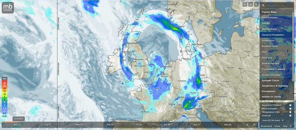
As the image shows above from Meteoblue, the low pressure that brought rain to many places over the weekend isn't finished with us yet bringing rain across Ireland, the U.K and Denmark over the next 24-48 hrs as it slowly edges eastwards. Some of that rain looks potentially very heavy across Sjælland later on Monday and continuing into Tuesday, with the eastern side of the island potentially being hit hardest maybe. One to watch on your rain radar for sure !
So continuing cooler and unsettled for most areas in the first part of this week with plenty of showers across Ireland and the U.K initially, with heavier rain for Denmark and north west Scotland. That threat of rain showers / heavier rain will continue through to Thursday but it'll come appreciably more confined to The North West and across north west Scotland and Denmark. As we approach the end of the week, a ridge of high pressure edges into Ireland and the southern half of the U.K, so that'll push up temperatures into the low to mid-twenties and settle things down a bit with lighter winds and plenty of sunshine with a largely dry picture from Friday onwards. That north west wind will remain in situ and that's what is going to keep the temperature down to below the mid-twenties. So we are now in a cycle of undulations in a stronger jet stream. One week the high pressure will push in before an Atlantic low nudges this out the way and introduces cooler, more unsettled weather, particularly to Scotland and the north of the country. On Sunday we start to see a new low pressure arrive and it'll introduce rain to Ireland as it pushes eastwards.
Weather Outlook
That's how it looks for next week, with an arriving Atlantic low pressure introducing a cooler and unsettled theme to the weather, particularly for the north and west of the U.K & Ireland and Denmark. So cooler with that north west wind continuing to peg back temperatures to a more tolerable level and rain showers for all areas in the first part of next week. That rain will be heavier for Ireland, Scotland and Denmark and more showery in nature further south, which will be drier and warmer. Some areas will see no rain further south next week. As we go through to the 2nd part of next week, high pressure will push in, nudge that rain more northwards and give us a warmer, drier more settled period of weather.
Agronomic Notes
From the 17th of July, we saw the humidity levels start to climb as the dominant high pressure responsible for the latest UK heatwave was nerfed eastwards onto the continent (and hence the reason for the hot weekend just passed in Denmark). Now high pressure systems rotate clockwise so as the system moved eastwards it's trailing edge pulled up southerly winds. Those winds were humid in nature.
Below is a chart showing humidity over the last 7 days from a location close to Plymouth, England. Now, the south west of England is a high pressure area for disease because the climate is warm and humid. The same is true in Ireland in the south west and along the south coast of Ireland and England. These areas experience higher pressure from disease full stop I think and particularly Dollar Spot.

You can clearly see the block of high humidity spanning the 15th - 18th July where it stayed a pretty constant 97-98% over this period. This meant pretty constant leaf wetness coupled with overnight temperatures ranging from 15.7°C - 17°C.

Great conditions for most of the turfgrass pathogens we encounter across the U.K, Ireland and Denmark. So that's Dollar Spot, Microdochium, Leaf Spot, Fairy Ring species, Waitea (with the high rainfall) and no doubt Anthracnose, after the trigger events in mid-June and early July.

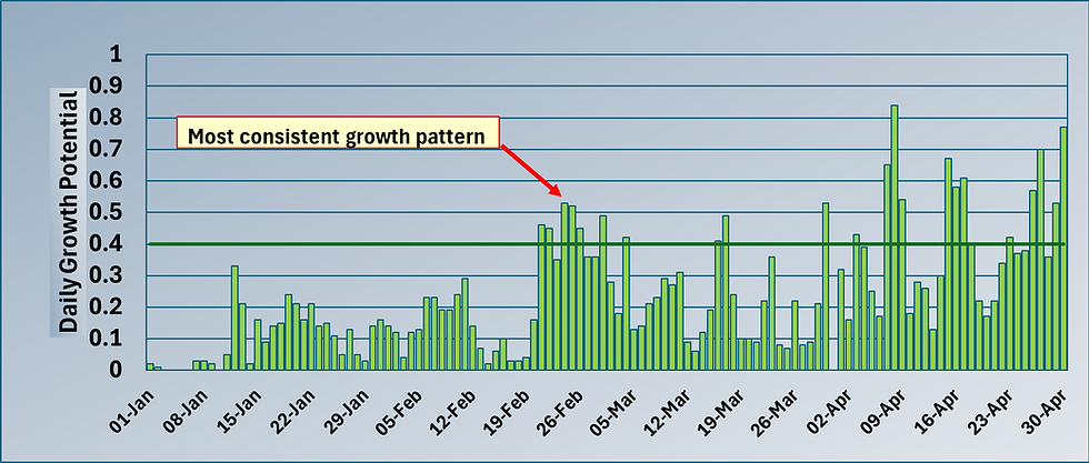
I charted out the Smith Kern's Dollar Spot Proabability model for multiple locations (shown above) across the U.K, Ireland and Denmark and you can clearly see the consequence of that hike in humidity last week with all locations showing a marked upward trend. Two locations leap out of the graph, Plymouth in the south west of England and Copenhagen in the east of Denmark. Both of them show extremely high pressure with the latter dropping back this week to be replaced with our north east of England location - Scarborough. If we apply the U.S model's agronomic assumptions to this model, we would have been applying multiple fungicides through this period, (> 20% Smith Kern's is the threshold) but the reality is that many facilities won't have done this, mentioning of course that either the product isn't available or the standard practice is not to apply a pesticide. Instead those facilities will be employing every bit of a non-pesticidal IPM program they can, be that mechanical operations like rolling to dew removal and plant hardeners and the like. When that pressure nudges close to 50% I think we are close to the point where you will see some activity despite everything. Interested to hear everyone's experiences of this period ?
Now that our weather pattern has changed I think we will still see this pattern continue because although the winds are north westerly in nature, they'll feed in humid air from the successive Atlantic low pressure into high pressure systems looking to push up from the south.
On the flipside to this disease pressure is an improving growth dynamic with the grass plant recovering from the high temperature stress events we have experienced of late (often shown as a depressed Growth Potential figure) so that means we are in a better position to grow diseases out of our surfaces. So it isn't all bad news and if you have lost grass cover, a dimple overseed and topdress will soon show benefits as the soil temperature is conducive to rapid germination. The healthier the grass plant, the less conducive it is to succumbing to plant disease. So yes, we are having a testing summer, but these breaks in the heat and high E.T stress allow both us and the grass plant to re-group and prepare for the next one as we are only in the 3rd week of July and I'd expect the risk of more heat from the south to remain till the end of August.
All the best to you.
Mark Hunt


Comments