
June 30th
- Mark Hunt

- Jun 30, 2025
- 9 min read
Hi All,

Back from a lovely stay in North Norfolk, no place like it and somewhere steeped in memories for me. Above is Cley beach looking up towards Blakeney Point. As you can see, Cley is a shingle beach so getting to this point and back is a 2 1/2 mile walk on the shingle (in waders !!!). I certainly burnt off some of those Two Magpies Bakery Cinnamon Buns (Kanelsnegle) !
Earlier in the week I had been Mullet fishing on fly further up the coast when a truck drove up the beach and an agitated person beckoned to me to come in from the sea (I had waded out). Geez I thought "What now?". As I made my way over I saw it was The Coastguard and a very polite man proceeded to explain that they had found WWII ordnance (in the area I had been fishing as the tide came in) and were in the process of blowing it up !
Well that was a first for me in terms of things that curtail my fishing !!!
Whilst over in Norfolk, it was a pretty hot week with a strong wind and I was thinking how much water this was evaporating from our already parched land. Indeed some locations I monitor recorded an evapotranspiration rate of 5mm per day + on five separate occasions as you'll see later when I look at soil moisture status. That's some level of stress for the grass plant.

I don't normally feature people and names in my blog, but this week is an exception.
Last week, we lost a great man in our industry, Adrian (Adi) Masters, who passed away after a short illness. Adi was my colleague for many years back in the days of Headland Amenity covering The South West. He was quite simply a cracking man and a true character who energised many a flagging evening with his Jethro accent, jokes and singing. And boy could he sing. 😉 The photo above is the only one I have ever seen when he isn't smiling or laughing, he had a 'dynamic sense of humour'. Indeed I spent a lovely late night session with Adi up in The Studley this year at Harrogate, we had a great catch up and I am so so glad for that time. He will, I know, be missed by his family, his colleagues, his friends and the many people that knew him.
Rest in peace Adi.

General weather situation - w/c 30-06-25
As predicted in my last blog two weeks ago, we have endured a second, consecutive high temperature peak in the jet stream over this weekend gone, with hot air streaming straight up from Africa. You can see it on the GIF above courtesy of tropicaltidbits.com and I am sure this and earlier month peak events will mean June 2025 will close as the warmest ever.
The jet stream currently is running far to the north allowing heat to build below it, but it is due to push southwards in the next few days and that'll allow a change in the weather to take place and perhaps some much-needed rain and cooler temperatures. So the heat builds to a crescendo today and is projected to bring our hottest June day ever, with temperatures pushing towards the mid-thirties and no doubt yet another 20°C night. Thankfully that change in the jet stream position will allow cooler, Atlantic air to push in and that'll drop both day and night time temperatures from Wednesday onwards, down to more usual temperatures for the start of July. That process has already started for the west of Ireland where it is currently 13.5°C and raining. This rain will push into Scotland overnight into Tuesday. With all of this heat, there is a likelihood of thunderstorms developing so remember to look at lightningmap.org if you want to see where they are and where they are heading.
Mid-week we could see a weak rain front push across central England and Wales, so maybe, just maybe they'll be some rain for the parched Midlands, one of the driest areas of the country. This rain is likely to push eastwards across The North Sea into Denmark on Thursday. As we approach the end of this week we will see an Atlantic low pressure (remember them ?) push rain into Scotland and Northern Ireland before this rain will move southwards on Friday / Saturday. The low will increase the wind strength and then push more rain across Ireland, the U.K and Denmark over the weekend.
So, we will start the week with temperatures in the mid-thirties or close to and end it by Sunday struggling to break into the twenties. I know which one I prefer !

Weather Outlook - w/c 7th July
Next week looks to start much fresher (bless) with some showers around and currently a weak low pressure is projected to push south of Ireland and maybe bring some rain to the southern coasts of Ireland and England (that may change). So cooler and unsettled at the start of next week for some areas and then we see a ridge of high pressure build. At this stage it doesn't present on the GFS as another heat dome but will bring temperatures up into the low twenties I think from Tuesday onwards until the end of the week when that lower-lying jet stream will allow another Atlantic low pressure to push into Ireland from the west. To me though, that heat is still there over southern Europe and it won't take much for another 'heat dome' to develop. Watch this space...

Agronomic Notes
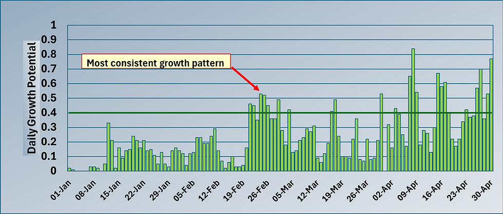
As mentioned earlier, June 2025 has been a brutal month for lack of rain and high ET (Evapotranspiration). Above is a soil moisture surplus / deficit chart from our Prodata Reports software using data from The Oxfordshire, Thame, England. The total rainfall for the month is currently 28.8mm, but the total E.T is 116.89mm, so the soil moisture deficit is -87.9mm up until the 29th of June. That equates to 879,000L of water per hectare or 879 cubic metres lost in June from the plant and soil.

I use an E.T level of 4mm per day as a plant stress threshold and if we look at the data above we can see 16 days out of the 29 so far exceeded this threshold in June. Point 1, June 2025 was a stressy month and that is pertinent for not only the status of the grass plant but also it's potential to develop stress-related diseases like Dollar Spot and Anthracnose. I looked back at our last hot summer, 2018, and to June 2018, a very hot and dry month. The total monthly E.T was 111mm, the following month, July 2018, we hit 132.7mm total monthly E.T, a record that remains to this date for this location.
Incidentally, it is why I use The Oxfordshire as my default location, thanks to Sean Wilson, the course manager, I have access to many years worth of data, from the same Davis weather station, in the same position. I can look back to 2005 to compare and contrast and for that I am very grateful.
The dry spell we are enduring isn't just confined to June as a month. If we look at the soil moisture surplus / deficit from the start of the year, we can see we began the year in a state of surplus, as is usual. This surplus carried on until the 3rd week of April when we entered a deficient soil moisture status. From then on we have been on a downward trend, with a slight hiatus at the end of May / early June, before carrying on inexorably downwards unchecked through the rest of this month.
Currently we are sitting at - 176.8mm for the year soil moisture deficit If we compare that to last year at the same point, we were sitting at +81.3mm. That's a difference of 258.1mm or over 10 inches of rainfall in old money. In 2024 and 2025, June was a very dry month, as can be seen from the similar shape of the graphs for this time period.

The last significant drought was back in 2018, so I went back and looked at some figures for June of that year. At this location, we had 2.4mm of rain and 111mm of E.T to give us a monthly deficit of -108.6mm, but the yearly, cumulative deficit was -73.1mm vs. -176.1mm for 2025, because the lack of rain started earlier this year than 2018 and has continued to the present day.
So we are very short in water with a continual drought from the end of April and still two months of the summer to go. It makes me wonder where we are in relation to water supplies now and for the future and how we will look when I type this blog in early September ?
Plant Health - Disease risk
So, I think (hope) I have clearly detailed that we are going through a very dry and very stressy start to summer. It's not all bad news, a dry spring and start to summer is good news for player numbers / rounds and it has stopped fertile roughs and semi-roughs growing, so less maintenance. As I type this blog at 15:30pm, the highest temperature on the Davis weather stations I monitor has just nudged to 33.4°C (Roehampton) and I anticipate it will keep increasing till early evening.
Such high day and night temperatures aren't good news for the grass plant because at high temperatures, let's say 25°C+ (though it differs between grass species), the rate of photosynthetic efficiency declines just at the same point that the respiration rate increases. Put simply the grass plant makes less energy than it consumes by biological processes including respiration. So it's on the back foot and therefore we need to help it during this time and for me that means maintaining adequate but sensible N (a task made easier now by measurement of clipping yield / growth ratio) to discourage diseases like Anthracnose / Dollar Spot. Using PGR's to manage growth, tillering, root development and plant stress and above all biostimulants based on humic acid and seaweed. Years ago I remember doing some wetting agent trials with at The Oxfordshire. With some of the treatments I tank-mixed a biostimulant with the wetter, others were just the surfactant and of course a control. We gradually reduced the irrigation input vs. E.T to induce plant stress, which started to show at around 30% replacement of E.T. The plots with wetting agent and biostimulant combined remained the healthiest consistently even as temperatures topped 30°C and with minimal moisture. The biostimulant contained a good quality seaweed mixed with a high concentration of humic acid and my findings matched up with some early research work that came out of Rutgers University. Long ago I know, with advances in technologies and delivery systems since then, but I believe the principle holds and especially for the weather / E.T levels we are enduring.

In my last blog, pre-Norfolk, I ventured the opinion that we were entering the climatic conditions conducive for the initial development of Anthracnose. Our disease model shown above for a location in Kent confirmed this with 3 days of consecutive high temperatures and plant leaf wetness. We are also likely to see the last two days of June and the 1st of July as another trigger. So we are put on notice that this disease is developing. Now geographically I have found this to be the case across the southern half of the U.K, extending up to The Midlands, East Anglia, Wales, northern England and Ireland. Scotland hasn't quite hit the climatic trigger yet due to lower temperatures in June, the same for Denmark as far as I can see.

The other disease that likes a weak grass plant under stress is Dollar Spot.
With increasing temperatures and humidity courtesy of that southerly airstream, we have seen a gradual increase in the Smith Kerns Dollar Spot Probability Model (SK for short)
So I decided to graph out for June 2025, the SK values from a number of different locations across the U.K, but also including West Ireland (though the figures aren't a mile off for the East of Ireland either) and Eastern Denmark. They all show a pattern of increasing SK values as we approach the end of June, with 3 locations increasing sharply - Limerick, Bath and Thame. It's no coincidence that 2 of them are towards the west of the country which tend to pick up a more humid airflow from The Atlantic and that'll raise the Dollar Spot threat. If we pick up more unsettled weather as the forecast suggests, then I see this risk increasing or at the very least staying this high.
OK, lots of number crunching there I know, plenty to think about, all the best in this heat.
Mark Hunt


Comments